- KINETA SURVEY - HP/WA: 085774400860, 081218677202 > Jual - Service - Kalibrasi - Sewa Alat Survey Murah
 click image to preview
activate zoom
click image to preview
activate zoom

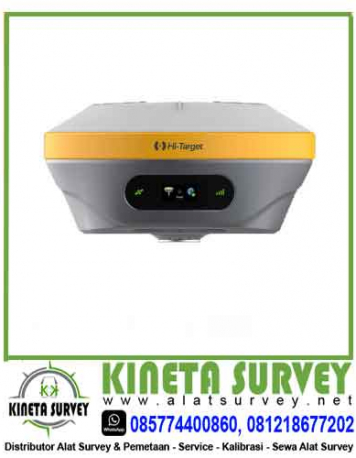
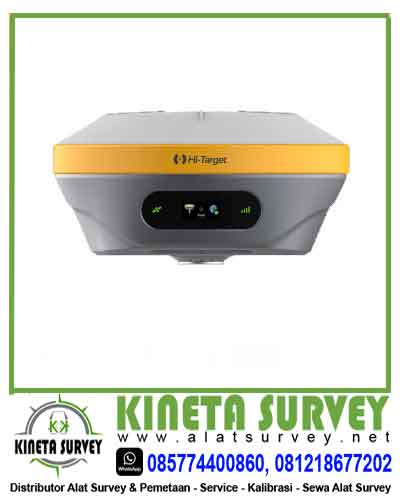
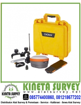
Jual GPS Gnss Hi-Target iRTK4
| Stok | Tersedia |
| Kategori | GPS Geodetic, Surveying Instrument |
Jual GPS Gnss Hi-Target iRTK4
 Jual GPS Gnss Hi-Target iRTK4
KINETA SURVEY, HP/WA: 085774400860, 081218677202, Distributor Pusat Jual berbagai macam Alat Survey, Drone & Pemetaan Seperti Total Station, Digital Theodolite, Automatic Level Waterpass, GPS Geodetic, Accessories, Service Kalibrasi, Sewa & Jasa Pengukuran Topografi TERMURAH di Jakarta dan Seluruh Wilayah Indonesia.
KINETA SURVEY menyediakan produk alat survey yang berkualitas, asli, serta bergaransi yang resmi. Kami juga memiliki banyak klien dari berbagai macam daerah yang sudah bermitra dengan KAMI karena harga yang kami tawarkan merupakan harga terbaik yang ada di pasaran seluruh Indonesia. Percayakan kebutuhan alat survey dan pemetaan Anda hanya di KINETA SURVEY
Spesifikasi GPS Gnss Hi-Target iRTK4
Gps Gnss Hi-Target iRTK4 is a full-featured, intelligent receiver system equipped with an integrated new-generation full-frequency antenna and advanced multi-channel engine, allowing users to attain accurate, reliable solutions. Users can also take advantage of calibration-free Tilt-Surveying without leveling the survey pole to collect point data in more places. In addition, the Smart Base function in iRTK4 automatically pairs the Rover with the Base by using Hi-Target global servers and ensuring communication by providing the best connection.The iRTK4 system can maximize your productivity in unprecedentedly challenging environments with these powerful features and Hi-Survey Road Field Software.
|
Features Gps Gnss Hi-Target iRTK4
|
|
Gps Gnss Hi-Target iRTK4
*Do not need to set up a reference station, no connection CORS,
to achieve a single real-time centimeter level accurate positioning;
*Positioning accuracy 3 cm; *Direct measurement of CGCS2000 coordinates; *Convergence <30 minutes, partial area <5 minutes; *Broaden the RTK application, can meet the Gobi, desert, lakes, reefs, oceans and other areas of high-precision positioning needs; |
|
Applications
|
|
Geophysical survey / topographic survey / navigation positioning / road survey / electric survey / pipeline survey / precision agriculture / aerial survey etc
|
|
New calibration-free tilt measurement
|
|
Gps Gnss Hi-Target iRTK4
*Using ultra-high precision inertial measurement module IMU, unique tilt compensation function, the practical RTK tilt measurement is realized;
*No correction, from the start of the moment, it is ready for accurate measurement, instant use; *Anti-magnetic interference, no fear-cut electromagnetic interference, anywhere can be used; *RTK measurement from now on really get rid of bubble shackles, measurement efficiency at least 20%, measurement accuracy is more secure; |
|
Built-in provincial CORS services
|
|
Gps Gnss Hi-Target iRTK4
*Boot is used, do not need cumbersome procedures, directly enjoy the province;
*CORS service, save time and labor; |
|
Smart Base Station Gps Gnss Hi-Target iRTK4
|
|
*Base station: intelligent selection of optimal server or optimal channels and protocols;
*Mobile station: just input the base station host number, you can automatically match the base station parameters in real time, the station has become very simple; |
|
Multi-protocol Built-in Radio
|
|
*Send and receive integrated multi-protocol built-in radio station, good compatibility;
*Radio power high and low three adjustable, typical distance of 7 km; *Support network relay, fill network blind area, improve efficiency; |
|
New Combined Antenna
|
|
*Will GNSS antenna ,4 G network antenna, WiFi antenna, Bluetooth day;
*High integration of line, further improve the quality of signal reception and transmission ,360° of the zenith signal communication without dead angle; |
|
Built-in eSIM card 4 G All Netcom
|
|
*Built-in eSIM network chip, including 3 years 4 G traffic;
*Set aside Nano SIM card slot at the same time, support 4 G all-Netcom; |
|
Android iHand30 thin
|
|
*Four-core processor big data easy processing;
*2GB RAM 16GB ROM built-in 4 G all-Netcom; *OTG; USB Type G interface support High capacity lithium battery supports fast charging; |
|
All protocol radio stations
|
|
*30W and 10 W with the heart switch, support radio full protocol;
*Anti-design, IP67, resistance 1.2 meters free drop, durable; *HD OLED display, five keys, easy to operate; |
|
Hi-Survey measurement software
|
|
*New interactive design – flat interface / smart base station / voice layout tips;
*Comprehensive road algorithm-support broken chain / ultra-high widening / slope lofting, support DTM surface lofting function; *Powerful base map display – support online map and dxf /shp data import display; *Open Interconnection – Support for message push/software online upgrades/file sharing; |
|
New measurement engine
|
|
*440 channels to support full constellation;
*Support Beidou third generation satellite and single north bucket calculation; *Strong performance, stable accuracy; |
|
Built-in battery to support PD fast charging
|
|
*Built-in lithium battery, no need to remove charge, waterproof more reliable;
*support USB PD3.0/45W super fast charging; *Charging time ≤3.5 hours, support portable battery charging; |
|
Station differential
|
*Support Hi-RTP satellite-based enhancement services (support L-Band)
|
|
GNSS configuration
|
*Number of channels :400+ *BDS:B1,B2,B3
*GPS:L1,L2,L5
*GLONASS:L1,L2
*GALILIEO:E1,E5a,E5b
*SBAS:support
*QZSS:support
*Output format ASCII:NMEA-0183, binary codes
*Location output frequency :1 Hz~20 Hz *Static Data Format :GNS,Rinex Dual Format Static Data *Difference scheme: CMR,RTCM2.X,RTCM3.0,RTCM3.2 *Network Mode: VRS,FKP,MAC; Support NTRIP Protocol |
|
System configuration
|
*OS: Linux operating system
*Start time :3 seconds *Data storage: built-in 8 GB ROM, support static data automatic cyclic storage |
|
[1] of accuracy and reliability
|
*RTK positioning accuracy: plane :±8 1×10⁻⁶ D) mm (D distance between measured points)
Elevation :±(15); and 1×10⁻⁶ D) mm (D distance between measured points) *Static positioning accuracy :±(2.5) plane 0.5×10⁻⁶ D) mm (D distance between measured points) Elevation :±5 0.5×10⁻⁶ D) mm (D distance between measured points) *DGPS positioning accuracy: plane accuracy :±0.25 m 1ppm; elevation accuracy :±0.50 *SBAS positioning accuracy :0.5 m *Initialization time :<10 seconds *Initialization reliability :>99.99 per cent |
|
Communications module
|
* I/O port :5 core interface, USB Type C interface, SMA interface, Nano SIM card slot
*Built-in eSIM card :(including 3 years of Internet access fee), no card can be connected *4G built-in network communications: TDD-LTE,FDD-LTE,WCDMA,EDGE,GPRS,GSM *WiFi communication :802.11 a/b/g/n access point and client mode, can provide WiFi hotspot services *Bluetooth Communications: Bluetooth 4.2/2.1EDR,2.4GHz *Built-in radio: Power :0.5 W/1W/2W Adjustable Spectrum :410 MHz~470 MHz Agreement: HI-TARGET,TRIMTALK450S,TRIMMARKⅢ,TRANSEOT,SOUTH Number of channels :116(16 of which are configurable) *External Radio: HDL460A Agreement External Radio Power :10 W\30W adjustable, frequency :403~473 MHz,
Agreement: HI-TARGET,TRIMTALK450S,TRIMMARKⅢ, TRANSEOT,SOUTH,CHC,SATEL Transmission rate :19.2 kbps/9.6kbps adjustable Channels :116(16 of which are configurable) |
|
Sensor
|
*Electronic bubble: realization of intelligent alignment
*Tilt measurement: built-in high-precision inertial navigation, automatic attitude compensation, no correction, anti-magnetic interference, point-to-point measurement, accuracy 3 cm. |
|
User interface
|
*Key: Two keys
*Display :0.94 inch 240*120 high resolution OLED high definition color display *LED light: satellite light, signal light |
|
Functional applications
|
* Premium features: OTG, NFC flash, webul interaction, firmware upgrade for u disk
*Intelligent application: intelligent voice, self-test, battery charging, intelligent base station *Remote services: message push, online upgrade, remote control *Cloud services: equipment management, location services, collaborative operations, data analysis |
|
Physical characteristics
|
*Mainframe battery: built-in high capacity lithium battery 6800 mAh/7.4V, network mobile station working hours [2]10 hours
*Support fast charge: support USB PD3.0 super fast charge, charging time ≤3.5 hours. Support portable battery charging. *External Power Supply :6~28 V Wide Voltage DC Design ,5 Core Interface *Dimensions :Φ156mmx77mm *Weight :≤1.25 kg( battery) *Power consumption: W 4.2 *Material: Magnesium alloy material for shell |
|
Environmental characteristics
|
*Dustproof and waterproof :IP68
Natural fall of 2 meter high measuring rod Relative humidity 100% non-condensation Operating temperature -30℃~70℃ Storage temperature -40℃~80℃ |
Kami menyediakan produk yang lengkap seperti, Total Station, Theodolite Digital, GPS Geodetic, Kompas, Automatic Level Waterpass dengan merk seperti Sokkia, Topcon, Nikon, Leica, Ruide, Mato, GeoMato, Mato, Minds, Gowin, Horizon, Spectra, South, Titan, Geomax, Geo Fennel, Minds, CHC, Trimble, Hi-Target, Horizon dan merk terkenal lainnya.
Siap Kirim Alat Survey /Alat Ukur Ke seluruh Kota Indonesia:
Jakarta, Tangerang, Bekasi, Cirebon, Bandung, Semarang, Jogja, Surabaya, Malang, Denpasar, Bali, Kupang, NTT, Mataram, NTB, Lampung, Palembang, Bengkulu, Jambi, Pekanbaru, Medan, Aceh, Sumatera, Riau, Batam, Pontianak, Palangkaraya, Banjarmasin, Samarinda, Balikpapan, Kalimantan, Makassar, Mamuju, Poso, Palu, Kendari, Donggala, Gorontalo, Manado, Sulawesi, Irian jaya, Papua, Sorong, Manokwari, Fak fak, Jayapura, Merauke, Nabire, Papua Barat & Seluruh Indonesia
KATEGORI PRODUK:
- Total Station
- Digital Theodolite
- Automatic Level Waterpass
- Laser Level Waterpass
- GPS Map/Navigasi
- GPS Geodetic
- Laser Level
- Laser Meter
- Kompas
- Baterai & Charger
- Drone
- Flagging Tape
- Handy Talky
- Kabel Data
- Laser Distance Meter
- Lensa Eyepiece
- Meteran
- Mini Prisma
- Nivo
- Pole Stick Prisma
- Prisma Polygon
- Prisma Single
- Rambu Ukur
- Reflective Sheet
- Single
- Surveying Instrument
- Tribrach
- Tripod Survey
- XRF Analyzers
- Accessories
Layanan Jasa Kami Lainnya:
- Jasa Pengukuran Topografi
- Jasa Service Alat Survey
- Jasa Kalibrasi Alat Survey
- Sewa Alat Survey Total Station, Theodolite, dan Automatic Level Waterpass
Kami Menerima Jasa Pengukuran & Pemetaan, Survey Topografi Jakarta & Seluruh Indonesia :
- Perencanaan Jalan,
- Saluran Irigasi
- Konstruksi Bangunan
- Proyek Perumahan
- Dan lain sebagainya.

Untuk informasi produk, harga dan penawaran bisa langsung menghubungi kami dibawah ini.
Kontak Kami:
![]()
HP/WA: 085774400860, 081218677202
Email: abdul.kineta@gmail.com , jamaludin.muchlis81@gmail.com
Jual GPS Gnss Hi-Target iRTK4
| Dilihat | 583 kali |
| Diskusi | Belum ada komentar |
Jual GPS GNSS CHC I76 KINETA SURVEY, HP/WA: 085774400860, 081218677202, Distributor Pusat Jual GPS Geodetic Comnav T300 dan berbagai macam Alat Survey, Drone & Pemetaan Seperti Total Station, Digital Theodolite, Automatic Level Waterpass, GPS Geodetic, Accessories, Service Kalibrasi, Sewa & Jasa Pengukuran Topografi TERMURAH di Jakarta dan Seluruh Wilayah Indonesia. KINETA SURVEY menyediakan produk alat… selengkapnya
HP/WA: 085774400860, 081218677202
Jual GPS Geodetic eSurvey E100 KINETA SURVEY, HP/WA: 085774400860, 081218677202, Distributor Pusat Jual berbagai macam Alat Survey, Drone & Pemetaan Seperti Total Station, Digital Theodolite, Automatic Level Waterpass, GPS Geodetic, Accessories, Service Kalibrasi, Sewa & Jasa Pengukuran Topografi TERMURAH di Jakarta dan Seluruh Wilayah Indonesia. KINETA SURVEY menyediakan produk alat survey yang berkualitas, asli, serta… selengkapnya
HP/WA: 085774400860, 081218677202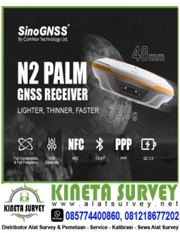
Jual GPS Comnav N2 KINETA SURVEY, HP/WA: 085774400860, 081218677202, Distributor Pusat Jual GPS Comnav N2 dan berbagai macam Alat Survey, Drone & Pemetaan Seperti Total Station, Digital Theodolite, Automatic Level Waterpass, GPS Geodetic, Accessories, Service Kalibrasi, Sewa & Jasa Pengukuran Topografi TERMURAH di Jakarta dan Seluruh Wilayah Indonesia. KINETA SURVEY menyediakan produk alat survey GPS… selengkapnya
HP/WA: 085774400860, 081218677202
Jual Theodolite Digital Ruide RT2 KINETA SURVEY, HP/WA: 085774400860, 081218677202, Distributor Pusat Jual berbagai macam Alat Survey, Drone & Pemetaan Seperti Total Station, Digital Theodolite, Automatic Level Waterpass, GPS Geodetic, Accessories, Service Kalibrasi, Sewa & Jasa Pengukuran Topografi TERMURAH di Jakarta dan Seluruh Wilayah Indonesia. KINETA SURVEY menyediakan produk alat survey yang berkualitas, asli, serta… selengkapnya
HP/WA: 085774400860, 081218677202
Jual Theodolite Digital Spectra DET2 KINETA SURVEY, HP/WA: 085774400860, 081218677202, Distributor Pusat Jual berbagai macam Alat Survey, Drone & Pemetaan Seperti Total Station, Digital Theodolite, Automatic Level Waterpass, GPS Geodetic, Accessories, Service Kalibrasi, Sewa & Jasa Pengukuran Topografi TERMURAH di Jakarta dan Seluruh Wilayah Indonesia. KINETA SURVEY menyediakan produk alat survey yang berkualitas, asli, serta… selengkapnya
HP/WA: 085774400860, 081218677202
Jual Automatic Level Leica NA720 KINETA SURVEY, HP/WA: 085774400860, 081218677202, Distributor Pusat Jual berbagai macam Alat Survey, Drone & Pemetaan Seperti Total Station, Digital Theodolite, Automatic Level Waterpass, GPS Geodetic, Accessories, Service Kalibrasi, Sewa & Jasa Pengukuran Topografi TERMURAH di Jakarta dan Seluruh Wilayah Indonesia. KINETA SURVEY menyediakan produk alat survey yang berkualitas, asli, serta… selengkapnya
HP/WA: 085774400860, 081218677202
Jual Digital Theodolite Marcdavis DT-23 KINETA SURVEY, HP/WA: 085774400860, 081218677202, Distributor Pusat Jual berbagai macam Alat Survey, Drone & Pemetaan Seperti Total Station, Digital Theodolite, Automatic Level Waterpass, GPS Geodetic, Accessories, Service Kalibrasi, Sewa & Jasa Pengukuran Topografi TERMURAH di Jakarta dan Seluruh Wilayah Indonesia. KINETA SURVEY menyediakan produk alat survey yang berkualitas, asli, serta… selengkapnya
HP/WA: 085774400860, 081218677202
Jual Digital Theodolite Topcon DT209L KINETA SURVEY, HP/WA: 085774400860, 081218677202, Distributor Pusat Jual berbagai macam Alat Survey, Drone & Pemetaan Seperti Total Station, Digital Theodolite, Automatic Level Waterpass, GPS Geodetic, Accessories, Service Kalibrasi, Sewa & Jasa Pengukuran Topografi TERMURAH di Jakarta dan Seluruh Wilayah Indonesia. KINETA SURVEY menyediakan produk alat survey yang berkualitas, asli, serta… selengkapnya
HP/WA: 085774400860, 081218677202
Jual GPS Geodetik CHC-i50 GNSS-RTK KINETA SURVEY, HP/WA: 085774400860, 081218677202, Distributor Pusat Jual berbagai macam Alat Survey, Drone & Pemetaan Seperti Total Station, Digital Theodolite, Automatic Level Waterpass, GPS Geodetic, Accessories, Service Kalibrasi, Sewa & Jasa Pengukuran Topografi TERMURAH di Jakarta dan Seluruh Wilayah Indonesia. KINETA SURVEY menyediakan produk alat survey yang berkualitas, asli, serta… selengkapnya
HP/WA: 085774400860, 081218677202
Jual GPS Gnss Geomax Zenith35-Pro KINETA SURVEY, HP/WA: 085774400860, 081218677202, Distributor Pusat Jual berbagai macam Alat Survey, Drone & Pemetaan Seperti Total Station, Digital Theodolite, Automatic Level Waterpass, GPS Geodetic, Accessories, Service Kalibrasi, Sewa & Jasa Pengukuran Topografi TERMURAH di Jakarta dan Seluruh Wilayah Indonesia. KINETA SURVEY menyediakan produk alat survey yang berkualitas, asli, serta… selengkapnya
HP/WA: 085774400860, 081218677202


NO. REKENING

Order di Marketplace Kami
Web & SEO: Nirwana Group
Belum ada komentar, buka diskusi dengan komentar Anda.